What's the weather where you are?

Hermosillo, Sonora.Mexico.
Last week there were 3 light showers. Today Sunday 22 July, from 43 it is going down to 41 ° c. For tomorrow, 47 ° is forecast.
Rain is expected Tuesday, Wednesday and Thursday, hopefully enough abundant and serve to refresh the environment.
 
Alarm in Southern Arizona before stifling heat.
(AP)
The authorities of Southern Arizona asked the population to take extreme precautions in the face of a wave of intense heat that led to temperatures of 50 degrees Celsius (122 Fahrenheit).

The National Weather Service said the thermometer could register between 44 and 48 degrees Celsius (112 to 119 Fahrenheit) until Wednesday in South and Southwest Arizona.

Through a message on Twitter, the National Meteorological Service asked residents to stay hydrated and in cool indoor environments.

The authorities "can not emphasize enough that this week the heat will reach extremely dangerous levels."

Meteorologists noted that the monsoon moisture will slowly return from the east over the weekend.

The Arizona monsoons are summer rains that can cause flash floods and strong winds

Seems to me that those are fairly normal summer temps for Arizona.
 
Yes, it seems that the news is incomplete, the extraordinary thing would be that throughout the state have these temperatures over a long period of time.
 
Heatwave West of Ukraine. At the end of July the summer appears to have reached its maximum strength. Humid, suffocating air, withering plants, growing cracks in dry soil. Gets hot fast in the morning, hotter in the afternoon. House walls suck in the heat - (adobe-brick mix) - and radiate it at night, interfering with sleep.

- - - - - - -
About four or five times since my last report, when such above intense developments felt they were going to lead to heat-waves, they were mitigated. In each case achieved were an air-conditioned outdoors environment with cool winds - lots of cloud shadow - bringing fresh air and the smell of rain, resulting in a pleasant room temperature inside, at night too.
Side effects:
As the summer heat got more vicious, the "outdoor-air-conditioning" had to battle the intensified heat as well, resulting in stronger side effects: successive soft rain, half-day rains, strong 1-2 hour "sheats of rain", cool air, too much cold draft. Almost getting a mild cold, joint pain or stiff neck, just like when an office air-conditioner is turned way up to battle the stronger heat-wave outside and the body of office workers get a cold shock.
 
  • Like
Reactions: Ca.
Heatwave continued to build up here West of Ukraine, promising really dry, hot air today by our "meek EU" standards. US residents would probably laugh this off as they are probably used to that Californian legendary extreme heat, devastating hurricanes, floods and super-strong winds + golf-sized ice balls and such weather, the like of which we never seen here in Hungary.

Still to our meek-EU standards, the whole day was looking to be crippling hot, preventing any work. I already saw myself just sweating, mind numbed from heat in the evening, no draft, no wind, unable to concentrate. Taking repeated showers in these cases gives little respite with any water evaporating off the skin fast. So I thought around noon:

- Well, now its getting really hot, 'top of summer'-strength! The heat marching forward so intensely, it seems unstoppable. Maybe its time I applied medium strength power? I tried to justify 'medium' with if its markedly hotter, one has to work harder if one wants to see it cool down, no?

So I did medium-strength.

Usually all seeded cloud layers evaporate even faster, when its really hot. But of course I always worry, if there will be problems.. from overdoing it?

The Delphi Oracle - as you'll see - is super-justified in warning people about:
Nothing in excess, Moderation in all things and Measure in all, affirms the importance of temperance (Gr: sophrosyne). Temperance is one of the four cardinal virtues.

(0-1min) Immediate gusts of wind as always when doing the mitigation, doesn't even surprise anymore, Don Juan loved to warn about this. (0-2 hours) Darker clouds have taken over the sky with continuous rumbling and visible lightning. Sudden rain, aggressively promises to be "sheets of rain".

As you can see, they already updated our meteorological data for our area for the past couple of **mitigated** days, but of course that 2mm rain forecast for today is a joke.. We already easily had like 10mm as I'm writing this, its pouring with continuous rumbling and visible lightning at 19:00pm. Some pepper-sized ice was mixed into the rain as well. This is also characteristic of an externally applied power. Sudden increase in weather intensity then it abates just as abruptly. This style "sudden rush -->then vanish", "violent energetic acceleration" then slowing to a complete halt -- couldn't reflect my personality better.

Its over now. We had 25mm / an inch of rain easily. Fully overcast & cooler now <== versus ==> how it promised to be in the morning with a vengeance: "a merciless sweltering heat the whole day and insufferable heat during the night" IF the heatwave were left running its course without mitigation.
 
Finally we have had rain yesterday evening and this morning here in north Belgium after several weeks. Yesterday was the hotest day ever since the wether reports exist in the region Oost vlanderen (east flanders) which the most important city is Gent (Ghent). The temperature there was 38.2 degrees Celsius (100.76 Fahrenheit)
 
  • Like
Reactions: Ca.
It's petty quiet on the southern border. Though at times some thunder heads creep in from Spain over this area.
All and all cool mornings with temps mild considering the continued global climate instability. Translated from French by Microsoft
#Climat with an anomaly of + 2.4 °c/medium 1981/2010 in France, July 2018 is located on the hottest podium since 1947, behind 2006 and 1983, and ahead of 2015. Warming of + 1.3 °c over 30 years between the periods 1959/1988 and 1989/2018.


Meanwhile much farther north of here.
 

Attachments

  • IMG_1555.JPG
    IMG_1555.JPG
    6.8 MB · Views: 6
Last edited:
Despite continuous hot weather, the national heatwave in the Netherlands is declared over -- due to a registration technicality.

Source: Two showers in De Bilt scupper chances of national heatwave record - DutchNews.nl

July 30, 2018

Despite the prolonged drought and new record temperatures in many places last week, 2018 will not go down in the history books as the year of the Netherlands’ longest heatwave – mainly because of a quirk of the record-keeping process.

A heatwave is officially declared if the temperature stays above 25 degrees for five consecutive days or more, including three days of 30-degree heat. However, the criteria must be met at the KNMI’s weather station in De Bilt, near Utrecht.

On Saturday, after 13 days of heatwave conditions, De Bilt recorded a maximum temperature of 24.2 degrees (link Dutch only), and the meteorological office declared the heatwave over. The KNMI’s headquarters happened to be one of the coolest spots in the country that day: only a few other weather stations on the coast fell short of the 25-degree mark.

As a result, the longest heatwave on record remains the 18-day stretch in 1975, which included six ‘tropical’ days above 30 degrees. The official end of the hot spell also meant that the public health service RIVM stood down its national heatwave plan, which advises people on how to avoid heat exhaustion and dehydration

Three weeks

NOS weatherman Marco Verhoef said that two short showers in Utrecht province effectively put paid to the chances of a record-breaking heatwave. The rain arrived at what is normally the hottest part of the day and stopped the temperature in De Bilt passing the 25-degree mark, while elsewhere in the province thermometers stood at 27 degrees.

‘If there had been another 10 minutes in between, De Bilt would have reached 25 degrees,’ said Verhoef. ‘Then we might have been looking at a heatwave of three weeks.’

Niet van het één of ander, maar De Bilt heeft nog geen 25gr gehaald vandaag. Gaat ook niet meer lukken ben ik bang; einde landelijke #hittegolf dus ….
pic.twitter.com/ZVzTZHqO1w — Marco Verhoef (@marcopverhoef) July 28, 2018

Although temperatures are likely to stay above 25 degrees for the rest of the week, the chances of another heatwave happening this year are slim, as another three days of 30-plus conditions are needed to meet the criteria.

De Bilt has been the home of the KNMI since 1897, when it moved out of Utrecht because the urban environment was distorting the temperature readings – buildings make cities warmer than the countryside in hot weather.

Local heatwaves are still in force in many cities, including Amsterdam and Rotterdam. The record for the longest regional heatwave – 22 days – may yet be beaten in Limburg, Noord-Brabant, Gelderland and Twente, where temperatures have been above 25 degrees since July 12 and are expected to stay there until at least August 6.


Other weather news updates:

Warm weather expected for Netherlands this week
Netherlands is "blind to drought", experts say
 
  • Like
Reactions: Ca.
it is hot here in California, it wil be all week upper 98f, but then again I guess it's pretty much a "summer time"... :lol::lol:
 
  • Like
Reactions: Ca.
July 2108 is in Denmark/Southern Scandinavia already the most sunny July on record since measurements began in 1920. Even the oldest members of society, unless they have immigrated from a warmer country, thus experience a summer of a lifetime. Juli er nu den solrigeste i dansk vejrhistorie: DMI
Little rain has fallen since April and for this reason, many farmers are selling out of their livestock, as they will not have enough to feed them in the winter and consequently need to save and work with less fodder usually be expected. At the same time many farmers have contracts for the delivery of excess straw to power and heat producing companies. This means, that in spite of their own needs, many are obliged to deliver straw as an energy source for the powerplants, who have moved away from coal in an attempt to be as GREEN as possible. This is not a problem for people who have no animals, but for those that do, they will have difficulty finding excess straw on the market, if they need it.

Right now, with more cattle going to the slaughteries, but with lower production ahead, one may expect higher prices for meat during the coming winter. The ministry of food has allowed ecological/organic farmers to use more solid feed for their cattle without loosing their status as being organic. In the old days farms were smaller and it was desirable for a farm to have som high areas, some low areas and a section of forrest for firewood, so as to insure that the farm in all circustances had a chance to survive dry years.

And what is the situation in Greenland? Try this page: Home: Polar Portal Then you can move to Greenland: Polar Portal and then Surface Conditions: Polar Portal
The overall trend appears to be moderate ice melting and a rather cold and wet summer.
Here is an explanation of the mechanics:
A lot of melting is expected the next few days, but if it can catch up with the expectations of "global warming" is to be seen.

Along the way, I found a Ph.D student who has an active Twitter account Zack Labe (@ZLabe) | Twitter He has a few tweets that are of interest. For example there is a diagramme of the rising amounts of methane, which has a tendency to get released from stores in the seas, if it warms up and from the Earth itself when the permafrost in the Arctic melts:

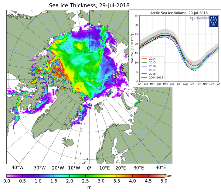
In the Twitter postings there was also a link to a time series of the thickness of the Arctic Sea ice:
The above model looks great, but is it true? I tried another model from the Polar Portal, prepared by DMI, and it does seem that things are a bit more icy compared to the end of the 2016 melting season, although we still have a few weeks before the freeze begins again.
CICE_combine_thick_SM_EN_20180729.png

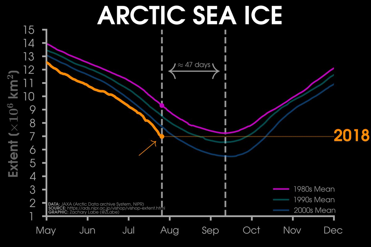
Here is another diagramme comparing the ice cover of the present with the past:
DjH_ixqUYAA21Q0.jpg

According to the above illustration the Arctic is short of 2 million square km of ice, if the past 1980'ies "Sovjet" level of glaciation in the arctic sea is to be achieved again. On the other hand, Nature is in flux all the time, why even try to think that the ice is missing this or that, when the earth already, geologically speaking is in a state of an ice age?

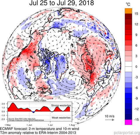
Below is a picture that shows the circulation of air and temperature anomalies from the usual average temperatures in the Northern Hemisphere. At the time of posting, it is showing the period between July 25, and July 29. Parts of Siberia are colder than usual (blue), as is Greenland and surrounding areas, whereas Western Europe and Western US are warmer (red). It is not written where the low and high pressure systems are, but we can deduce from the direction of the wind. In the Northern hemisphere, a high pressure system makes the air flow clockwise, and a low pressure system spins the air counter clockwise. This means that the current high pressure system over Western Russia lets the arctic air down into Russia, where the air warms up and moves over central Europe and up over Scandinavia. And over the Atlantic, there is a low pressure system because we notice the air vortex is spinning counter clockwise. The low pressure system west of the UK brings warmer air from the south which then in the present situation joins the warm air from Eastern Europe to make many parts of Northern Europe warmer than usual, especially since the low pressure system in this instance did not cross the UK and move east, but remained in the West, although this pattern could change in the coming days.

Wthr_Anom_NAO_SM_EN_20180729.png


There was also a link to an article, which might hold a clue as to some of the observed weather patterns in Eurasia, and who knows, might even give an idea of how an ice age could be brough about by a period of global warming.
A stratospheric pathway linking a colder Siberia to Barents-Kara Sea sea ice loss
Pengfei Zhang1,2,*, Yutian Wu2, Isla R. Simpson3, Karen L. Smith4, Xiangdong Zhang5, Bithi De1 and Patrick Callaghan3
Science Advances 25 Jul 2018: Vol. 4, no. 7, eaat6025. DOI: 10.1126/sciadv.aat6025
Abstract
Previous studies have extensively investigated the impact of Arctic sea ice anomalies on the midlatitude circulation and associated surface climate in winter. However, there is an ongoing scientific debate regarding whether and how sea ice retreat results in the observed cold anomaly over the adjacent continents. We present a robust “cold Siberia” pattern in the winter following sea ice loss over the Barents-Kara seas in late autumn in an advanced atmospheric general circulation model, with a well-resolved stratosphere. Additional targeted experiments reveal that the stratospheric response to sea ice forcing is crucial in the development of cold conditions over Siberia, indicating the dominant role of the stratospheric pathway compared with the direct response within the troposphere. In particular, the downward influence of the stratospheric circulation anomaly significantly intensifies the ridge near the Ural Mountains and the trough over East Asia. The persistently intensified ridge and trough favor more frequent cold air outbreaks and colder winters over Siberia. This finding has important implications for improving seasonal climate prediction of midlatitude cold events. The results also suggest that the model performance in representing the stratosphere-troposphere coupling could be an important source of the discrepancy between recent studies.[/QUOTE]Can warm arctic water, a factor when global warming turns into global cooling? It might be as water absorbs more energi, and water an release more humidity to the air than ice. Humid air moving across a cold surface will release moisture and it could be snow.

Below is a model of the ice cover over the seas north of Scandinavia, Northern Russia/ Western Siberia.
Reconstruction of Arctic Barents-Kara sea ice extent changes over the last millennium
July 20, 2018, Science China Press
Read more at: Reconstruction of Arctic Barents-Kara sea ice extent changes over the last millennium
Qi Zhang et al, Reconstruction of autumn sea ice extent changes since AD1289 in the Barents-Kara Sea, Arctic, Science China Earth Sciences (2018). DOI: 10.1007/s11430-017-9196-4 [...]
Under the influence of global warming, temperature in the Arctic has increased more significantly than the global average. However, winter extreme cold events in Eurasia including China, have become frequent in recent years. This trend is obviously contrary to global warming. Severe weather with cold surges, ice-snow and frozen rain occurred in southern China in 2008, and the overwhelming "boss-level" cold wave that attacked almost all of China in 2016 caused heavy casualties and property loss. Scholars believe that these events are closely related to the rapid decline of Arctic sea ice. [...]
5-reconstructi.jpg

What is mysterious in the above diagramme, compared to the earlier graphs, is that the level of ice in the Barents-Kara sea appears to have been lower in earlier parts of the 20th century. Does this not contradict other graphs, and models, or is it just that different areas of the arctic seas have been covered?

Leaving the above criticism for now, at the end of the previous article there was a link to a related article, also by Chinese researchers, which has a useful graphic representation that attempts to explain how there can be cold weather in China and by inference north of China, in Siberia, when the ice has melted in Barents-Kara sea:
Arctic warming to increase Eurasian extreme cold events
May 16, 2017, Chinese Academy of Sciences

Arctic warming to increase Eurasian extreme cold events
arcticwarmin.jpg
https://3c1703fe8d.site.internapcdn.net/newman/csz/news/800/2017/arcticwarmin.jpg
Sketch map of the possible physical process between Arctic warming and Eurasian cold events. Credit: Yao Yao
In the above illustration, which highlights the movement of the jet stream, notice that the high pressure system spins the air clockwisem, whereas the low pressure system does the opposite, thus making things colder for Central and Eastern Asia.

Surprisingly, what we have had the past few months is a series of unusually stable high pressure systems over Western Russia and parts of Scandinavia. Had this happened during winter, would we have witnessed freezing cold in China, as explained by the research papers.
 
  • Like
Reactions: Ca.
Back
Top Bottom