What's the weather where you are?

Incoming depression from storm Miguel, off the Atlantic.

Translated from French by Microsoft
The passage of the cold front associated with the storm #Miguel and the effect of stormy showers in the trolling on the temperatures modelled by ARW 3km.

Translated from French by Microsoft
The storm #miguel tackles the Atlantic façade on Friday morning with strong winds gusting to 100/120 km/h on the Vendée and the Charente. Stay informed ▶️ PREVISIONS METEO FRANCE - Site Officiel de Météo-France - Prévisions gratuites à 15 jours sur la France et à 10 jours sur le monde

 
The Netherlands hasn't encountered any further mayhem. Friday and the weekend will be normal for this time of year.
 
The current weather patterns for this week are in a wavy pattern. Even slightly chaotic!
As of June 5th, still seeing mild snow in the higher elevations. Wax on.

Translated from French by Microsoft
Significant medium-term uncertainty with very divergent scenarios from 13 June. The weather forecast becomes very complex beyond that. Highlighting of the bad reliability with the "spaghetti" T ° maps of the air mass. More information > > Meteo Paris - Le premier site météo pour Paris et l'île-de-France

500hPa Geopotential Elevation Anomaly (Cold Drop Demonstration) - June 9-14, 2019 - GFS / TropicalTidbits Model
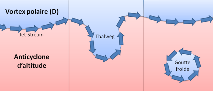
A cold drop is a closed altitude depression, that is to say cut off from the general circulation from west to east marked by the jet stream that separates the polar air from the fresh air. As it passes, the vertical thermal gradient (the temperature difference between soil and altitude) increases, creates instability (showers, thunderstorms), and brings fresh air.

goutte_froide_aout_2017_02(1).png

Schéma d'une goutte froide - Info Météo
Instability and fresh air, a cocktail that will dominate the next few days on our territory. We should mainly observe temperatures below seasonal norms (except extreme south-east), all under fairly frequent rainfall in almost all regions.

Temperature anomaly and rainfall accumulation - period from 9 to 13 June 2019 - Model GFS / ClimateReanalyzer

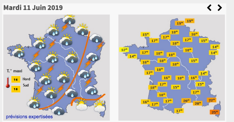
For illustration, here are the forecasts for the day of Tuesday, June 11, potentially the poorest of our week to come: frequent showers, sometimes punctuated with thunderclaps and a few wind squalls ... all under particularly cool temperatures for a mid-June (we will struggle to approach 20 ° C, even near the Mediterranean!).

a9f1ff3776f5f6403a56cb6e416c4ab4.png

Weather forecasts assessed - Tuesday 11 June 2019 - Weather-Cities

But a cold drop is the real obsession of weather forecasters. It produces a large amount of small-scale phenomena particularly poorly apprehended by the models. A small change of shape or position can change everything about the weather at home. And if the situation seems to be wedged until Wednesday / Thursday, the trend is much less clear, or even totally anarchic beyond this date. In the second half of the week, the evolution of this cold drop is not at all surrounded by all the digital models. This causes major divergences in the forecast, and offers a multitude of sometimes opposing scenarios.

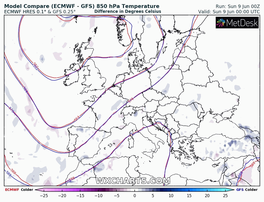
As an illustration, here is a comparison between the two main models (the European ECMWF, and the American GFS) in terms of air mass temperature (here at a reference altitude of 1500m). If the two match up to Thursday, June 14 included (0 ° difference), a significant divergence appears as of Friday, June 15 (difference of 5 ° or even close to 10 ° C between the two numerical models for Wednesday, June 19 ).

gUB07XZr14.gif

Air mass temperature differences (altitude 1500m) between ECMWF and GFS - June 9-19 , 2019 - WxCharts

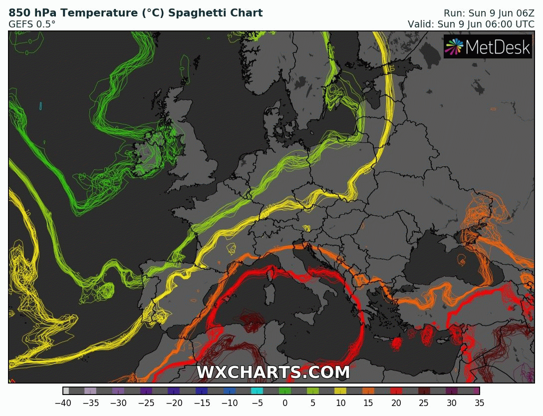
An even more ambiguous proof of this uncertain trend: the so-called "spaghetti" cards. Take the example of a spaghetti card on the same temperature parameter of the air mass at 1500m. Each color line indicates a precise temperature of this air mass (green = 5 ° C, yellow = 10 ° C, orange = 15 ° C, etc.) according to 20 initial scenarios (GEFS set models).

The goal is simple: compare these 20 scenarios. When these scenarios provide the same time, these spaghetti lines are confused or very close to each other. When the scenarios diverge, these lines end up intertwining, and highlight an uncertainty. Again, we then distinguish lines of similar temperatures until Thursday, June 13, before the total blur ...

JDnEuWe24c.gif

Spaghetti map of air mass temperature (1500m altitude) - 9th to 17th June 2019 - GEFS / WxCharts assemblers

To summarize: if the reliability of forecasts remains correct until Wednesday 12 or even Thursday, June 13, the uncertainty becomes very large or even maximum beyond this date. From warm, sunny weather to cool, cool weather, and vice versa, our forecasts could unfortunately fluctuate drastically for a few more days ...

In the face of these regular changes in forecasts, or in the face of the frequent indications "to be confirmed" or "very uncertain" published on our sites, we advise you to consult (or re-consult) this article dedicated to the good reading of the weather forecasts ( click here >> )

In the meantime, do not hesitate to consult very regularly our detailed forecasts and appraised , updated daily to take into account the most plausible scenarios.
 
The drought continues unabated here on the Northern Tablelands, NSW, Australia. Very little rain has fallen over the last few months and most here agree that this is the worst drought since the Federation drought of 1901.

Fortunately the winter so far has been relatively mild apart from a couple of cold snaps.

Though most forecasters predict very little rain for the next 6 months, the GFS forecast shows an interesting prediction for the coming days for the Australian region. I have never seen a forecast model show such a large area (albeit mostly over ocean) of heavy precipitation, for so many days, especially in the southern area around Australia and New Zealand.

The forecast may not be accurate, but the coming days will be interesting to watch and see what happens.


GFS Medium Range Forecasts of
Vertical Velocity and Precipitation

Issued: See Image Titles for Initial and Valid Times

Forecasts are issued by the National Centers for Environmental Prediction (model documentation) and are presented as a set of seven panels for each 24 hour interval from 0 (analysis) to 144 hours.
colaline.gif


aus3.00hr.png

aus3.24hr.png

aus3.48hr.png

aus3.72hr.png

aus3.96hr.png

aus3.120hr.png

aus3.144hr.png
 
Looks like the forecast model is showing a more "normal" outlook now, must have been a glitch. This was my first thought, but the model was consistent for around 36 hours or so.
Sorry for the noise.
 
  • Like
Reactions: Ca.
This hot weather has been going on for a couple days now, from beginning this week: forecast temperatures on the right are in °C and humidity or not --> these temps feel HOT West of Ukraine!
30479

I was standing down since November, because temperatures were naturally cool, until now.. Even last week I made a noble and heroic [sic] promise that this summer I won't touch the weather, no matter how hot it becomes. A cool summer apartment will solve this problem. Until then I need a camera, so I can take photos to prove these outlandish claims of mine. One photo of untouched weather + forecast pic from this site, then subsequent photos about the invited "anomalies".
Right now you see a hot day in the forecast, but outside there is again this 'storm-clouds anomaly' surrounded by clear blue summer skies. A nice mass of dark-grey sudden-storm clouds that came out of nowhere: now closer to how I pictured, while attempting to create a couple of cold-cosmic-potentials in the sky with foreboding masses of dark clouds and mucho mucho rain!!
 
Last edited:
  • Like
Reactions: Ca.
Just now: big blotchy rain and loud "cannon-shot" lightning arrived thundering away forcefully with violent gusts of wind -- mirroring my personality and manifesting with full physical Nature force exactly of what I pictured in my mind, while creating the Cosmic Potential of Cold in the sky. Unfortunately I let my discipline go and also pictured heavy ICE hail falling - which just arrived in these moments.

I should have been a lot more careful!!!! Don't have money to pay for the roof. ((([Aarrrgghh] Stupid Stupid me*100!!!))) :scared::curse::boat:

Imagine clear blue skies in the East, then above us the anomaly is hammering away with ~10mm size iceballs / hail.
 
Last edited:
Now with sheets of rain too.. 10 minutes later: Now the winds are stronger and the ice is falling like bullets being shot from a browning machine gun. The soil was so heated up from previous heat that all the ice melts.
 
Done! Even the drizzling has stopped now. Young plants / seedlings survived. Got away with a sudden storm not doing much damage. Whew! In the Middle-Ages witches were probably burned for any worse than this.

(((I figured that as a preparation for a possible future - involving an invasion scenario - for training to get into 'combat shape', further practice with fist-sized hail will be done best in the wilderness with no living areas. A wooden-roofed, robust shed? Or a custom built, "thick plastic roof" serving as a shield? Maybe shaped like a bathtub to hide under? Because I think a natural cave might collapse from larger ice impacts: when for combat-practice intentionally invoking a lot stronger 'nature force anomaly', using full psychic power. )))
 
Very hot weather in Macedonia. This morning at 7:00 am Temp was 20C. During the day it will go up to 30-35C.
Later in the afternoon are possible local strong thunderstorms with a lot of rain and hail.
The temperature itself is not a big problem. Problem is when you are under direct sunlight. Even 25C under the direct sun is very hard to deal with.
Maybe this is because the Magnetic shield of the Earth is weakening and all solar radiation and cosmic radiation is coming more easily through the atmosphere.
Another thing that I noticed is that there is so much vegetation everywhere like never before.
Also, there are a lot of snakes out in nature. I don't know why but if you go out in near mountains you will find a lot of snakes like never before.
Yesterday some friends were outside for a short walk in the woods and they saw 9 snakes. I also saw one this year a few weeks ago in the countryside, climbing on the stone stairs of the house.
Maybe all these drastic changes in the climate and changes in our planet earth can be sensed much more by the animals that we humans can.
 
Thank You, c.a. you gave me this amazing idea! Temperature inversion A'la The Day After Tomorrow (2004). No excess rain, no hail, some lightning on the side, but nothing serious: just copious amounts of COOL AIR.


How to do it:
You begin this by uploading the usual 'Cosmic Cold Potential' into the sky (which sky apparently works as a remote server-computer) and your "injected code" = the cold-energy-potential becomes active! Then you - like a professional orchestra conductor - begin to just just further direct & extend the program = see above pic. This "code" injected into the sky [computer] turns out to be very responsive! You just imagine in your mind how it should further behave and you work on it on remote access like a hacker operates his stealth program uploaded unto a remote server. The original idea came from the movie The Day of Tomorrow! Couple days ago I messed up, because during and after the storm it was still HOT and WET. So to create an air-conditioner effect - by using this technique described below - you create a COLD DOWNDRAFT with some probable storm.

Weather change progression:
1. Its so hot, it gives the feeling of desperation. No chance in heck for a drop of rain, no clouds in the sky, total summer heat, danger of getting a heat-shock.
--- two standard interventions later [begin at ~~08:00am]
2. Haphazard clouds appear all over the sky and a focus is a bigger patch of a thin cloud umbrella that is just enough to dim the sun somewhat -->its still HOT
--- one more standard intervention later [at ~~10:00am]
3. Definite gathering of clouds. Some places begin to become a slightly darker gray
--- Now you begin with the above new technique "The Day of Tomorrow":
--- Safest way I thought without causing excess rain or god-forbid hail is to invite/create a large hole in the sky through which "-12°C / 10.4°F" air is streaming down. Stupid number, I know, I must research upper atmo temps properly, but this stupid number came to mind. I was wondering if a minus cold downstream --> mixing with the HOT DRY air here below on the ground --> will the effect be still palpable or not? [begin at ~~13:00]
4. Completely overcast with some cold drizzle. Cold winds - noticeable! Couple days ago with the hail it was HOT WINDS!! By now the entire region over the city turned dark-grey overcast with the clouds around the atmospheric hole looking like FROSTED WINDOW GLASS (will look up this cloud type for later). COOL / cold air is streaming down. No rain, but those clouds look FROZEN!

Edit: progress --> with big, forceful, blotchy raindrops it began raining. Remote soft thundering..
 
Last edited:
No hail!! WhooO-hooo! Superb cold drafts cooled down the summer heat, which usually keeps on torturing the populace with hot nights as well. Now its finally cool inside! The weather stabilized from medium-strength rain to beautiful soft rain, which is looking to end any time now. There was low to medium-loud thunder with occasional flashes. Electricity flickered twice. I think this one turned out to be amazing! Enough rain for the crops, but not dangerously cold to freeze anything.
 
Yesterday another batch of thunderstorms struck the Netherlands, mainly in the South and East of the country. One student (18 yo) was struck by lightning and severely wounded. Thirteen others (between 16-18 yo) in the near vicinity incurred minor injuries. Multiple fires broke out due to lightning and caused damages, but no one was injured. One thatch-roof barn caught fire and was completely destroyed. The storms also brought large hail stones with them. Social media was flooded with photos showing hail stones the size of ping-pong or golf balls.

For next week a real heat wave is expected to engulf the country.

Details here:
Fires caused by lightning strikes; struck student admitted to burns center

Year's first heatwave expected to hit NL next week
Temperatures set to hit 35 degrees next week - DutchNews.nl - Live
 
Yesterday afternoon a big storm with heavy rains and thunders over the western part of Macedonia.
In the town where I live there were a lot of flooded streets, shops, basements.
At the pick of the storm, there was about 50-60 cm of water on the streets. It was good that it lasted only about 2 hours max. If that storm would last longer it was gonna be a real disaster.
 
Back
Top Bottom