What's the weather where you are?

Here in NRW, Germany, is soooo hot! It is 33 degrees (34 real feel) but it feels like 1000. Due to light overcast, the air is very heavy and one cannot breathe. 2 days ago was 36!!!

We have kids pool at the balcony and I lay in there for a while, but as soon as I get out I´m again soaking wet from sweat in 10mins.... :nuts:
 
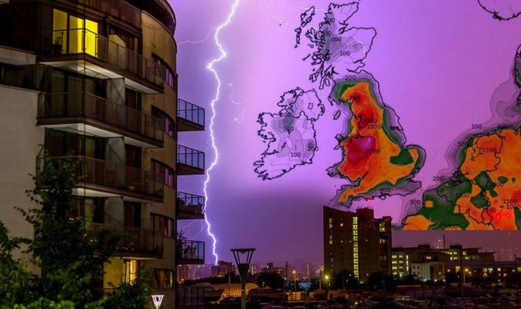
As in the US, the storms in the UK this week are also quite special: severe lightning storms with rain and hail sparking flood alerts, as a rare weather phenomenon is set to hit the country. Writing on Twitter, the meteorological organisation said: “An enormous amount of predicted CAPE over the coming days, giving the potential for some severe thunderstorm development across the UK, quite a rarity.” CAPE stands for Convective Available Potential Energy and is used as an indicator for thunderstorms. Last night parts of Wales and Manchester saw brutal lightning storms and the rest of the UK can expect the same until Thursday.

1597154049286.png


CAPE: Convective Available Potential Energy. A measure of the amount of energy available for convection. CAPE is directly related to the maximum potential vertical speed within an updraft; thus, higher values indicate greater potential for severe weather. Observed values in thunderstorm environments often may exceed 1,000 joules per kilogram (J/kg) and in extreme cases may exceed 5,000 J/kg.

Hmmmm, very interesting....
 
Hello,

In Quebec (Canada), it is hot and humid. Today it is 82 F and the humidity is 80%. It is variable here. We have had a lot of rain and cool days for the past few weeks. Honestly, it's pretty normal for us in Quebec.

Have a good learning !
 
I learned a new word today. “Derecho”


a line of intense, widespread, and fast-moving windstorms and sometimes thunderstorms that moves across a great distance and is characterized by damaging winds.


A derecho came through Iowa today producing 90-115 mph sustained winds for about a half an hour. Being in the Midwest I’ve always dealt with severe Thunderstorms and tornadoes, but I’ve never seen winds like that in this area. My street alone probably had a good 40-50 trees blown over.


Front of our house
Yes, it was a bad one.
I got to test out my new used generator last night. The power was out here for about 14 hours, much of the surrounding area is still without power.
Trees & power lines down all over the place, traffic lights not working, semi trucks blown over, etc...
I was driving through town when it hit, my little pickup ('99 nissan frontier) felt like it was going to lift off and fly away. Saw a transformer explode in the rear view mirror.
Some old buses caught fire due to downed power line:
Good times.
The damage to the crops here in Iowa can be seen from space.
An early estimate is 43% of the crops in Iowa was “impacted”. 10 million acres worth.
 
Maximum temperatures. August heatwave arrived! We are being roasted in Hungary, ~90 miles west of the Ukrainian border. No hope for rain. This always happened so far, so it's typical for this time of the year: clear blue skies with punishing, intense sun.
..
Yeah, but.. its my city, under my protection! I'm always effectively mitigating this, as you know.
 
Australia has seen some record lows last week, snow in areas where it hasn’t snowed in decades.

Temperatures dropped to -14.2 degrees Celsius just after 6:00am — a new record low for the state and even colder than Antarctica.

In mid north coastal NSW, today was lovely though: blue skies and top temperature of 22*C. Spring is in the air, and flowers are starting to bloom.
 
The Netherlands has gone through a record heatwave last week interspersed with some hefty thunderstorms in places. For the first time since regular measurements started (1901) we have had seven days of tropical temps (above 30° C) in a row.

With a seven-day average temperature of 33.1 degrees, a new high mark was set for the hottest week on record in the Netherlands. The previous record was set in 1976, when one week in July had an average maximum of 32.0 degrees, according to data from meteorological agency KNMI and a report from Nu.nl.

On Wednesday, the country had its first ever stretch of five days where temperatures topped 35 degrees, and also for the first time, seven straight days where the temperature in De Bilt, Utrecht peaked 30 degrees. That record was extended to eight days on Thursday in the Utrecht town, home to the KNMI.

The previous record of six days above 30 degrees was set in 1941, and met in 1975. Last year, Maastricht residents dealt with 15 tropically-hot days in a row.


All details here:
Heatwave continues, but thunderstorms are increasingly likely - DutchNews.nl
Ever hotter heatwaves are not recognised by weather models: KNMI - DutchNews.nl
Temperature tops key 30 Celsius for seven days in a row, with more to come - DutchNews.nl
Storms cause local floods and tree damage, more expected tonight - DutchNews.nl
Heatwave set to end with thunderstorms on Thursday night - DutchNews.nl

Record shattered for hottest week in Dutch history
Heat warnings downgraded as cooler weather approaches
 
Unseasonably cool in SW France. Was down to 16 C this morning and didn't go over 26 here all day. And now, another very cool night ahead.

We really have not had a full summer though we have had a handful of hot days in spikes interspersed with cooler weather.
 
Unseasonably cool in SW France. Was down to 16 C this morning and didn't go over 26 here all day. And now, another very cool night ahead.

We really have not had a full summer though we have had a handful of hot days in spikes interspersed with cooler weather.
That's interesting!

We also have unusual weather in Copenhagen. Felt like boiling today. 30 degrees celsius with 34 real feel. Since danes don't really know about air conditioning their busses and metros are boiling at 40+ celsius. Insanely hot this week.
 
I live on a sheltered peninsula on vancouver Island.
Thunderstorms are very rare here, we are at sea level on the pacific ocean, without altitude or mountains to build up cumulus clouds.
Last night there was a very strange fast moving storm and lightning with absolutely NO Thunder.
The lightning was very strobe like, and almost constant, and lasted for about an hour.

These pictures are stills that were taken from a video by my cousin.
She lives approx 80 km up-island from me.
She said that they could hear a very low, sustained rumbling.
1597703402016.png1597703416917.png1597703436355.png1597703468601.png
 
Yesterday was a new record temp in Anchorage at 78F. Where I live it was around 85F estimated - it's usually 5-10 degrees warmer, being further from the inlet. Today is another hot one.

For the summer, the weather was not too hot, but the cloudy days were warmer than normal. I've had my windows ajar all summer. Today I turned on my ceiling fan - it's so hot.

Also... I saw a spider yesterday, and realized its the first one I saw, and then I realized I hadn't seen daddy long legs either.... Doom!
 
It's cloudy this morning in these parts of SE Wales.

We had a week of the windless sun until last Wednesday, August 12th, at 9 pm, when it started to storm with thunder, lightning and rain. Both the rain and the sun have been present intermittently daily since then. The wind has been picking up too and it was the windiest yesterday it has been in perhaps the whole of August.
 
Back
Top Bottom