What's the weather where you are?

In the Netherlands, temperatures have been modest all week (around 20° Celsius at daytime and around 10-12° C at night, except for the frosty ones mentioned above) and today this was trumped with summer storms bringing heavy rain -- mostly in the center, the east and the south of the country causing flooding, slow traffic, traffic jams and tailbacks aplenty.

Details here:
Heavy showers expected tomorrow
Summer storms trigger flash floods and waterlogged buildings - DutchNews.nl - Live

In Dutch:
Heftige regenval, flinke files, en het wordt 'nog wel drukker op de weg'
 
Thick cloud-covers developing regularly each day for at least 2 weeks by now, bringing little rain and some cool temps. At least the killer sunlight can't get through! I love this weather. Close to what all of you reported, only our temperature averages are nicely just below unbearable heat!

When it doesn't conform to ~25°C, I'm making sure that it does!
weather.png

Volleyball toss:
I have developed a new technique costing very little energy, about ~30% compared to the energy requirement of one of the previous interventions. I'm calling it a barrel-bomb. In one of the well done kung-fu movies there was a octogenarian bald master in red monastery outfit rolling a large stone boulder in & around his arms, shoulder and head and obviously directing serious chi-energy, because he in now way was strong enough to even lift the ball with mere physical strength. I got that ball rolling motion-idea from that movie!!
Rolling a blob of energy as large as this medicine-ball - you picture in your mind this ball of energy created and floating in front of your belly and you move your hand along its surface in a circular motion as if you were spinning--grooving--creating the energy. Then after a couple of rolls, when you feel the ball of energy is concentrated--groomed enough "in your hands" and ready you toss it up into the sky like in volleyball - preferably toward where the sun is - and you visualize that the energy reaches the "sky-dome" and explodes in a white-transparent shockwave: covering a large area. So this isn't point-shooting anymore.

This consistently creates frequent, large-scale, thick cloud cover. No violent gusts of wind, no thunder, no sheets of rain. Very mild rain only. Brings cool air or at least prevents temperatures reaching critical levels => blocks out the heat-wave inducing, 'Killer Summer Sun' for good! Excellent energy ergonomy. Consistent. Large-scale effect.

I think I'm Kantek-forming Terra in our area. Or "Terraforming Earth" into the image of Kantek:
- Frequent cloud cover
- Bioluminescent clouds, glowing mists, bioluminescent oceans, grass & shrubbery
- All above ensured consistent ambient lighting, even as Kantek was further away from the Sun, e.g. there should have been less light, lower temps than on Mars.
 
Last edited:
Here in west Wales it's hot and sunny, about 26-8 degrees. I've walked about 6 miles today, just doing errands and visiting peeps. I've sweated buckets doing the walking, but I feel a lot better for having done it, fitness-wise. Great to be back home and chilling on the forum though. Temps in my region are much the same for the week ahead, but with some risk of storms.
 
SlipNet, in south Wales it started to hail with thunder and lighting around an hour ago. The hail ceased and was followed by rain. The water levels rose dramatically in a very short space of time.

The temperature has been warm all day, consistently in the high 20° range, with sunshine and a slight NW breeze.
 
In Alaska we have overcast skies, and finally some rain! It's still warm though. It was about 70-75F earlier, now it is about 65F.

On my trip to the store I noticed some parched grass and leaves from landscaped areas, but the natural plants are still green.
 
It is just after 4 am here and I am up after a few hours of disturbed sleep due to the heat. However, there is a lovely thunderstorm going on inland right now so I am getting a good view. Hopefully, it will send some cooler weather this way! I don't do heat! Me am red-haired, blue-eyed, paleskin. Heat not good. I wonder STO and STS are having a tiff and it is manifesting in this realm as the storm. I wonder if the C's do requests? Hey C's! Send some cooler weather this way, please. That would be great, thanks *kisses*.

Yay! The storm is here :thup: . Thank you C's :love:
 
Last edited:
@SlipNet, in south Wales it started to hail with thunder and lighting around an hour ago. The hail ceased and was followed by rain. The water levels rose dramatically in a very short space of time.

Yep, woke up today to black clouds in the sky, very muggy temperature-wise. Probably gonna get a shed-load of rain today.
 
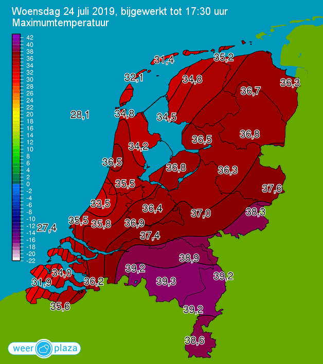
As is the case in most of Europe, the Netherlands is engaged in a series of heat record breaking this week, which probably will culminate in another official heat wave (at least four days in a row above 30° Celsius) and then likely been terminated by heavy thunderstorms during the week-end.

Yesterday the record was set at an unprecedented 31.6° Celsius (in De Bilt); today multiple records were established at several places successively ranging from 36,1° C in Gilze-Rijen at 12:10 PM (later on toppled there with 39.1° C at 3:00 PM) through to 39.3° C in Eindhoven at 5:30 PM (see chart).

article_5313_6cfea6bd-24d_image_large.png


For all the details:
Hottest 23 July ever measured; even hotter day ahead
74-year-old Dutch heat record shattered: mercury rises past 39.1
It has never been hotter since records began: temperature tops 39C - DutchNews.nl

In Dutch:
Hitterecord: 39,2 graden in Eindhoven. Bekijk hier hoe warm het is in Nederland

For the next two days the forecasts are: same or even higher, with more records probably.
 
In the Netherlands new records have been set since for the first time ever temperatures reached 40+ degrees Celsius at several places. It was hottest in Gilze-Rijen with 40.7° C during the afternoon. With 40.6 degrees Westdorpe was slightly lower than Gilze-Rijen. Also in Wilhelminadorp, Woensdrecht, Eindhoven, Arcen, Hupsel and at weather station Twenthe the 40 degree mark was passed. In De Bilt too it has never been so hot: 37.5 degrees Celsius, reports Weeronline.

Details here:
Another extremely hot day expected in NL; temps up to 40ºC
Hottest July 25th ever in NL; 10th heat record this year
Dutch thermometers top 40 degrees for first time ever after brief debate
Smog alarm issued for multiple Dutch provinces

It is still getting hotter; temperature reaches new record at 40.4 Celsius - DutchNews.nl

In Dutch:
Een nieuw hitterecord: 40,7 graden.

Wider context from SOTT:
Belgium and the Netherlands record all-time high temperatures as another heatwave cooks western Europe -- Sott.net
 
Continuing in the same vein: today was the hottest 26th July ever measured with 36° C in De Bilt and 40° in Volkel but the records from yesterday will not be repeated or surpassed. However, the heat wave is now official and last night we also had the warmest night ever measured with 22.9° C in De Bilt as the lowest.

Details here:
NL officially in a heatwave after hottest night ever measured.
It's official - a heatwave and the hottest night on record - DutchNews.nl

In Dutch:
Weer een record aan diggelen: warmste 26 juli ooit gemeten
 
Heatwave report from West of Ukraine:

Remember their prognosis of the heatwave for our area days ago?

Here, I put their prognosis from Tuesday ON TOP
and
I went to their site and I found their modified prognosis for today right there at the time of this post ==> I put it on the bottom: ( they might edit it again as observations reports come in)

- Oh, My Gosh! Right now as EU is stricken with a HeatWave.. I'm feeling the wonderful effects of overcast East, overcast West and a cool draft coming into my room, because I did NOT let this famous and powerful Heatwave heat up the ground and our house all morning and at / from noon!!

WHAT HAPPENED TO THE HEATWAVE??
:rotfl::lol2:;-D:-D:lol2::huh::phaser:

weather2.jpg
 
Last edited:
Thermometer outside shows 25°C with an overcast sky. There are very nice cool drafts, West of Ukraine. When the sun breaks through, you feel in a couple minutes its going to get hot real fast! No cigar!
 
Sunday Heatwave begins with a spotless, clear sky and blazing sun, not a cloud in sight. Its gonna get hot!! This has gone on all Sunday morning West of Ukraine! Meteorologists were really rooting for that weekend heatwave.. then when that situation changed, they rooted for at least a Sunday heatwave, so they can have a nice red temperature spike on their charts, so it looks good. Sorry... to trash your dreams, meteorologist ladies & gentlemen..

Last night I was .. mkhrm... otherwise occupied so I slept until high noon. Unattended, the heatwave began to heat up everything in the morning, all was roasting under the searing sun, as you can well imagine.

In two and a half hours, after applying 3 or 4 of the "Volleyball-toss"-technique, there is wind. Warm wind, but still.. and there is substantial cloud cover now with those thicker, grey-belly clouds:
As you can see at the meteorologist camp, they already had to take down even that puny Sunday "record high" temperature spike! None! As if it never existed..
 
Cooling was achieved via strong cold gusts of wind toppling very light equipment then a quickly brewing storm from the east with remote thundering sounds West of Ukraine. Western sky remained lighter, only got overcast now somewhat. Strong drafts create some resistance when closing a door.
 
Back
Top Bottom